September 10th
I wake up to the blasted guard’s radio again. It’s a beautiful morning, ideal for photography, so I decide to go up with Bosco to morning Mass. Soraya comes too. Last year when we came here the church was a building site. It’s still not complete, but almost there. Building work is focusing on the new Presbytery being built alongside the church.
Inside the church is like a hangar. The brick walls are enormous; it’s far bigger than the cathedral at Shyogwe. There is bunting decorating the metal beams that support the tin roof. There’s an enormous unobstructed central space. The building is light and airy, and the furniture – altar, cupboards etc – are tasteful. The altar is a flat slab of stone supported on a curved structure clad in local stone from the river beds. It is very effective and remarkably tasteful. I’m just realising I never took a picture of the interior, but never mind. Perhaps Soraya did.
The service is short and formal; the singing lively and accompanied by a drum. Unfortunately the building is so big and bare that the acoustics aren’t good. They need some fabric wall hangings to absorb the sound and give the resonance more warmth. The people are the same as last year. Schoolchildren, in uniform, are in church on their way to school, their textbooks placed on spare benches at the rear. Peasants, some on crutches, leave hats and hoes at the door (but just inside the church this year rather than outside, as last year – perhaps someone has been pinching their tools while they pray). A couple of toddlers break free, and today more exciting than even watching the drummer is the chance to goggle at two muzungus.
After breakfast Soraya and I saddle up with Jéremie and Bosco and head off deeper and deeper into Nyabinoni. Today I’m “off on one”. I’m going to the two furthest out schools of all, Kibingo and whichever of Gisura and Ngaru turns out to be the school at the bend of the river. (It turns out to be Ngaru, so Gisura misses out. Sorry, Gisura, but you are an Anglican school so perhaps Michael can get out to you). We stop at Gisura on the way, but by that point I’ve made up my mind where I want to go. I’m on a geological away day as well as visiting schools, and I don’t care!
I try ringing Kibingo to ask if it’s OK to visit them today, but the school is deep in a gorge-like section of the Nyaborongo valley, and there’s absolutely no phone reception at all. I don’t like doing this, but we’ll have to “bounce” them and arrive unexpected.
Talking of bouncing; that’s just what we do for about an hour: bounce on and on along the “main road” up the Nyaborongo valley. We are perched midway up the mountainside; the road endlessly twists round spur after spur of hillside. The Nyaborongo writhes below us like a brown snake, with brilliant green rice fields lining its banks. The sky is blue with just the odd fluffy cloud heading westwards towards the Congo. Row after row of mountains disappears westwards into a blue haze. On the far (west) side of the valley we can see roads, houses, schools, churches – Ngororero District; another whole chunk of Rwanda which I’ve never visited. Life’s too short.
Eventually we dive precipitously downwards into the valley and emerge on a rocky outcrop overlooking the precise spot I’ve wanted to go to ever since I arrived in Muhanga. It’s the confluence of the Nyaborongo and Mukungwa rivers. It’s the point where the Nyaborongo, after flowing steadily north from its source in Nyungwe forest, suddenly makes a 300 degree turn to flow south eastwards towards Kigali. It’s a phenomenon known in Geography as river capture and is the most spectacular example I’ve ever seen. A real earth scientist’s happy hunting ground. I try to explain what’s going on to Soraya and Bosco; they humour me by pretending to understand. What makes the confluence all the more startling is that the two rivers are entirely different colours. While the water flowing down the Nyaborongo is thick brown with eroded soil, the Mukungwa river flows clear. Where they join, the denser Nyaborongo water dives under the clearer stuff, to emerge a few hundred metres further down and slowly mix into a pale café latte colour.
It’s difficult to get a really good photo because of trees in the way; I’m furious with myself because when I get home I find the photo I’ve taken doesn’t do justice to the place.
Here we’re standing in the southern province. Across from us, the meeting point of the rivers divides Rwanda into three provinces; the south, north and west. A few miles on and we’d be into Kigali province, and after that the eastern province. Follow the Nyaborongo river and you see all of Rwanda. The Nyaborongo river is Rwanda and it feels like a friend to us because we’ve been within sight of it so many times as we’ve visited our schools here.
On we go, mile after mile (all in all about an hour’s moto ride from Nyabinoni presbytery, and easily four hours from Gitarama). I’m glad we’re not trying to do this journey in one continuous run!
The road gets narrower; even the main road has grassy strips in the middle. We come down right to river level. The combined river is enormously wide in places, with mudbanks. Men are paddling dugout canoes laden with cow grass – boats on the Nyaborongo are extremely rare and thus noteworthy. Villages line the edge of the road, peeping out from endless banana plantations. Down here in the valley the air is much hotter than the cool heights we’ve got used to. We seem to be entering a gorge, with towering mountainsides coming right to the edge of the river and almost no land for agriculture except the very banks of the river, which must be liable to flooding every rainy season.
Against all the odds, we come to a big metal girder bridge. It links nowhere to nowhere, and is only being used by pedestrians. Somebody, years ago, decided that this strategic place was where there ought to be a bridge, and laboriously hauled enormous girders up here to build it. But nobody got round to improving the roads on either side of the river. Now the bridge sits, forlorn and forgotten, with nothing at all on its north side and a tiny village of bedraggled bars and dodgy looking food places on the south. I suppose eventually they might surface the road we’ve just come along, but the truth is that they’ve found easier places to build the main north to south roads, and this bridge is a failed backwater. Here the river is narrow, very deep, and flowing faster than we can go on our motos.
A few miles more after the bridge and we reach Kibingo. Kibingo is my “ultima thule” – the furthest out school you can possibly get to within Muhanga. In church terms Bosco tells me that it is part of the Ntarabana (Rongi) parish, because it’s actually closer to Rongi than to Nyabinoni. That sets Soraya and I thinking. When we went to Ntungamo last week we noticed the road heading northwards close to the river. Here at Kibingo the road is heading south close to the river. If we were to go on a few miles I think the two ends would meet up. We are plotting to go back to Rongi in a couple of weeks time because we both have schools there we want to visit, and if we do so I’m going to indulge myself again and hire a moto to explore the few miles up from Ntungamo and see if our theory of the roads meeting up is right. If so we’ll not only have been to the furthest out place in the District, but we’ll also have done the giant loop of roads all round the river – albeit not in one go. (That would require a very long day and a backside made of cast iron).
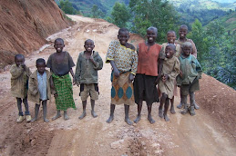
Kibingo is a completely rebuilt school with plastered and emulsioned walls. It would be a delight if it weren’t so isolated. The head turns out not to be there, but the adjoint knows both of us from training courses and welcomes us. He’s not in the least fazed by our “bouncing” him without warning. You can just imagine how few visitors they get here! The school has one solitary secondary class, with two teachers, and is losing numbers. Since January it has gone down from the giddy heights of 37 students to today’s 25. The primary is also small. It’s not so much that Kibingo is desperately poor (well it is, but no more so than anywhere else in Nyabinoni); it’s more a case that it is just so isolated that people are leaving in droves to find work and land elsewhere in Rwanda.
And there’s a nasty story in the playground. The yard is grassy and slopes down from the road to the school buildings, which are about 50 yards from the river but just high enough to be out of reach of floods. But last year, at the height of the rainy season, nemesis struck. There is an abrupt break in the slope of the playground. Thousands of tons of earth and rock debris slipped in a landslide and at one point threatened to engulf this new school and destroy part of it. There was a frantic appear for parents, other villagers, and pupils to rush to Kibingo and dig the school out before it became structurally unsound. Fortunately they succeeded, but the job is only half done. There’s still no retaining wall to hold back the earth, which now ends as a jagged wall about four or five feet high and about six feet from the classroom walls. The soil will move again as soon as it gets saturated with rain. The rainy season is about to start; 2009 is an “El Nino” year and the Government is already telling people that the rain is expected to be unusually heavy and concentrated. I think they’re asking for trouble at Kibingo. All it needs to safeguard the buildings is a couple of dozen perforated pipes sunk horizontally into the edge of the landslip to drain it and reduce the lubrication effect of rain water. I’m glad Soraya and I have come here; having seen the state of so many schools in the north of Muhanga it would be an absolute tragedy if this one was destroyed, even if nobody was hurt in the process.
(Spare a thought for poor Soraya; she’s had two geology lessons within an hour this morning!)
We watch lessons at the school. I watch History in the secondary section. The young girl (probationer, no training, no resources except her own notes from high school) is teaching about the Malian Empire, and comparing it with the earlier Ghanaian Empire. The children duly copy notes from the board all lesson. At the end, and acting on a hunch, I come out to the front and draw a rough map of Africa on the board. Then I ask any of the class if they can show me where Mali is on the map. Not a hope. One boy puts a cross exactly where Rwanda should be. Another puts Mali somewhere in Sudan. The rest just shuffle in their seats, nervously.
In this secondary school there is not a single atlas. I tell the teacher later that she should have drawn a map to locate these places, but it’s difficult to criticise her when the place is so starved of resources. So I promise her a set of Brucey rice sacks with maps of Africa etc for her boss to collect the next time he’s in Gitarama. She manages a smile.
Then I watch a primary yr 5 science lesson. The teacher is covering “wind” (the atmospheric type…). He takes the class outside onto the grass and we sit for twenty minutes in the blazing sun while he tries to get pupils to focus on the effects of wind. They’re not used to practical work (but I’m already minded to give him an “excellent” because he’s the first teacher I’ve met in Rwanda who’s prepare to go outdoors to study the environment). Eventually the pupils twig that he’s asking them to think about the banana tree branches which are being whipped into a frenzy by a fierce wind blowing down the Nyaborongo gorge. We talk about the bad effects of too much wind, but he seems to forget how the wind causes soil erosion on exposed earth. I want to try to prompt him, but I don’t know how. Then I see that just by my feet (I’m sitting on a big lump of rock that came down with the landslide) there’s some bare soil. I pick up a handful and crumble it between my fingers. The wind blows a thick plume of soil particles right down the school yard, past the assembled class. The teacher takes the hint, nods at me, and asks me to do it again so the pupils can see. Suddenly wind erosion is there, fixed in their minds. And all it took was a handful of dirt!
We debrief and have to search for our motos. Bosco and Jéremie are hungry and have gone up the road to find a bar and get something to eat. (Bosco has insisted on giving up his priestly duties all day to ferry me around; when I protest about this he insists that receiving visitors is part of his job in any case. I think he’s glad of the chance to do something different and an excuse for a day out up country). Near to Nyabinoni itself everybody recognises him and speaks to us, but the further we get from the big new church the fewer people know him. At Kibingo there’s a “succursale” (chapel of ease), but its Father Peter and Father Bernard from Rongi who trek up on their motos once a month to take a service. I think Bosco is quite enjoying being a bit more anonymous out of his particular patch!
Back we go, past the metal bridge where we stop for photos. A gang of cycle delivery men are pedalling enormous sacks of yams across, and they think it’s a hoot that a muzungu and a shinwa wan them as foreground in their pictures. They don’t ask for money; they just giggle like kids when we show them their photos and enlarge so they can see their own faces clearly.
We return to the bend on the rivers, and climb a few hundred feet to Ngaru, the school which stands right on the confluence. I really could never work here; I’d be looking at the view all day long. The school is on a narrow ridge with panoramic 270 degree views. I used to think the view along the Dorset coast from Woodroffe School in Lyme Regis was pretty unbeatable, but it has met its match at Ngaru. It’s just a pity that Ngaru can’t have a fraction of the proper buildings and equipment at Lyme Regis!
Ngaru is the usual wretchedly poor school, with buildings looking like derelict cowsheds. And yet….. Three cheers for Donatelle. Soraya saw her teach a year 1 class and told me to go and see her. Donatelle came to one of our trainings at Nyabinoni school last year, and has put everything we said in practice. There’s energy in bucketsful, and this at half past three on an equatorial afternoon. She has year years 2 pupils doing role plays in good English. They are acting, moving all round the room. They are singing, standing up and all being active and participative. The lesson is an absolute tour de force and I almost stand up and give her a round of applause at the end. She really is the tops. Who would have thought we would have found such a dedicated and brilliant teacher in this out of the way little place? She gets almost a clean sweep of “excellent”s in my official observation form, and I’m happy to say that the form will go into her professional record file. And I’m going to write a short note to Claude so that he’s aware he’s got a world class teacher in this remote village.
By the time we eventually leave and get back to Nyabinoni we’re almost too weary to eat, let alone plan for tomorrow. But what a day it’s been!
Best thing about today – absolutely everything except the state of our bottoms after hours on motos. Why can’t VSO charter a helicopter for these way out places. And you can stuff all your Kigali-based delights. For all the isolation and lack of amenities, we’re having the time of our lives out here. I drag Soraya out to look at the stars last thing before we go to bed and you couldn’t really wish for anything better.
I’m so much going to miss this place when I return home to England in December!
Tuesday, 15 September 2009
Ultima Thule in Muhanga District
Subscribe to:
Post Comments (Atom)


No comments:
Post a Comment